Mon Jul 15 2024
Half Dome, California
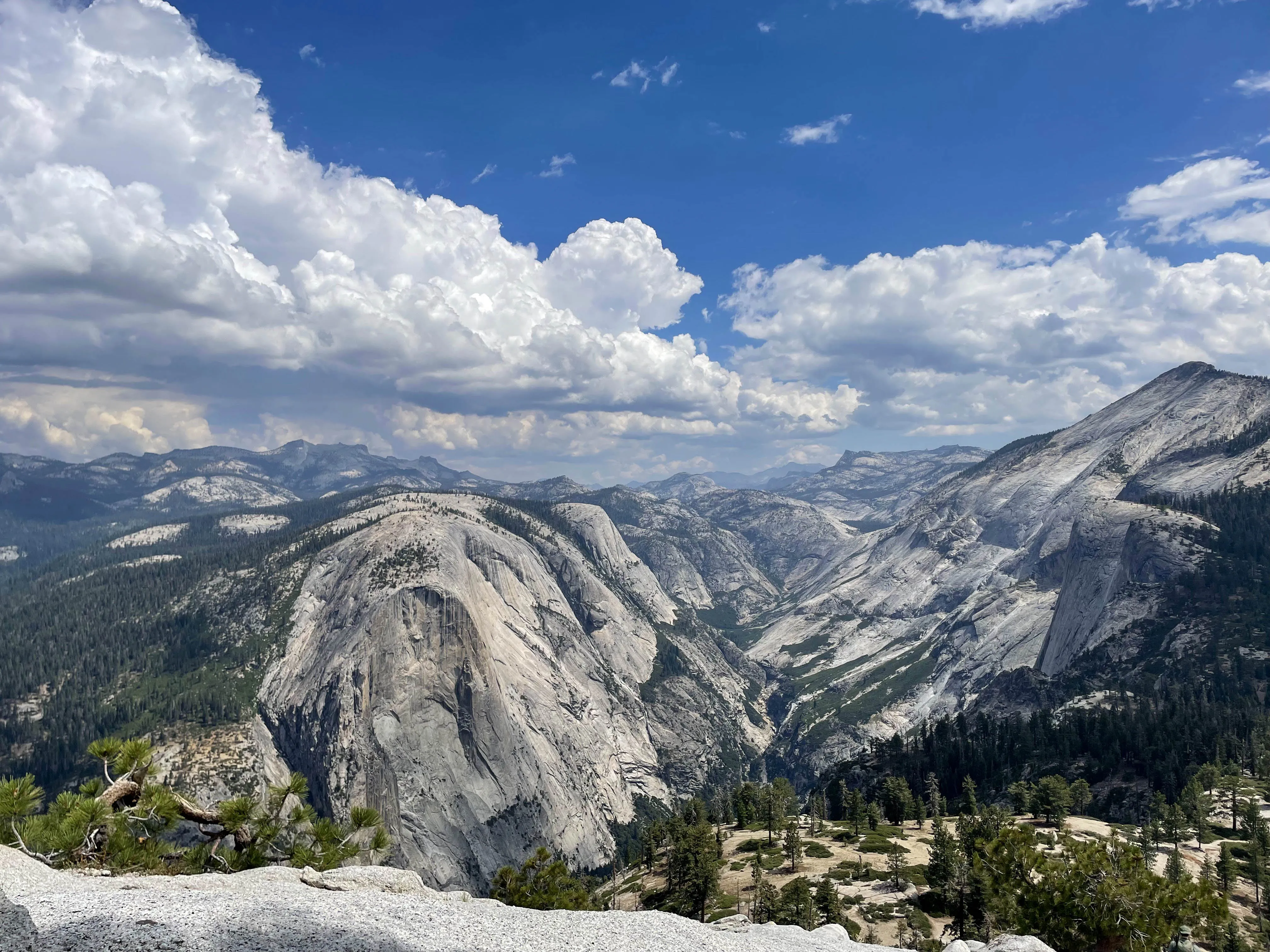
One of Yosemite's greatest offerings, Half Dome is itself a unique and distinguishable rock formation that can be viewed from the valley. The route to the peak of Half Dome is a challenging hike not for the faint of heart but will offer views of the Sierra Nevada.
Metadata
Time to Complete: 10-12 hours
Distance: 16.5 miles
Elevation Gain: ~4800 ft, starting at 4000 ft
Trail Type: Out and back
Difficulty: Strenuous. Long day hike with a steep cliff at the end. Arm muscles required.
Reservation: Seasonal lottery and next day reservations can be obtained via Recreation website.
Season: Spring through fall. It does get hot in the summer but there is a decent amount of shade.
Cost: This is located in Yosemite National Park so national park entrance fees apply. Enter before sunrise and it is free.
Planning
Refer to the map above. An itinerary helps make sure everyone is on track in order to make it back down at a reasonable time. Here is an example of a schedule:
| Marker | Time (example) | Approx. Distance (mi) | Approx. Elevation (ft) | Place | Comment |
|---|---|---|---|---|---|
| 1 | 5:40am | 0 | 4000 | Begin hike at Happy Isles Bridge | A short walk from the parking lot. |
| 2 | 6am | .8 | 4500 | Vernal Fall Footbridge | Only chance at potable water and flush toilets. |
| 3 | 6:20am | 1.2 | 5000 | Top of Vernal Fall | Will be misty and slippery. You may get wet. |
| 4 | 7am | 2.3 | 6000 | John Muir Trail Junction | There is an outhouse nearby. The trail will start to level out. |
| 5 | 7:50am | 4.4 | 6100 | Campground | Fill up on river water with filter. There is also an outhouse here. If you choose to make this a multi day hike, this is the campground you’d be staying at. |
| 6 | 9:45am | 6.9 | 7700 | Subdome | This portion starts to get steep and is also where permits are checked. |
| 7 | 10:30am | 7.4 | 8400 | Cables | The time to do this really depends on your arm strength and fear factor. |
| Peak! | 11am | 7.9 | 8800 | Top of half dome! | Congrats. Rest up. |
The Rundown
Preparation
Reservation
Reservations are required for the final most thrilling portion of the hike. The permit system changes over the years so be sure to check the lottery dates and obtain your permit at Recreation.gov. Day before permits are also available for trips on a whim and conveniently located on the same website.
Training
The hike was not as intimidating as it seemed and can be done with a healing sprained ankle. Just stay fit, do some hikes, and don’t trip.
How To Get There
Yosemite National Park has 5 different entrances depending on where you’re coming from. Some nearby towns to stay at for the night include Incline, El Portal, Lee Vining, and Groveland. However, they are all quite far from the trailhead, which means a long drive before the hike. The trailhead is located deep in Yosemite Valley and the nearest parking lot is Yosemite Valley Trailhead Parking Lot. There are campgrounds and cabins in the valley that require reservations but could be a good option for an early start.
Packing Essentials
- Gloves are very useful for the cables portion. Not only does it provide extra grip to pull you up but will contain the sweat while you are holding on for dear life
- Approximately 4L of water per person is apparently recommended but 2L should be enough for dry individuals
- Electrolytes of your choice
- A water filter is a good idea for hot sunny days to carry less weight and fill up by the river
- Lunch and snacks are always delicious
- Sunscreen to dodge skin cancer
- Bug spray may be nice to have in some areas
- Headlamp if you plan to return past dark or start before sunrise
- And of course, your permit
The Hike
We started the hike before the sun came out but didn’t really need the headlamp for very long. The first landmark is a bridge right before Mist Trail begins. This is your only chance at flushable toilets and water fountains. There are two paths that go towards Half Dome, Mist Trail and John Muir Trail. We chose to take Mist Trail up and John Muir Trail down.
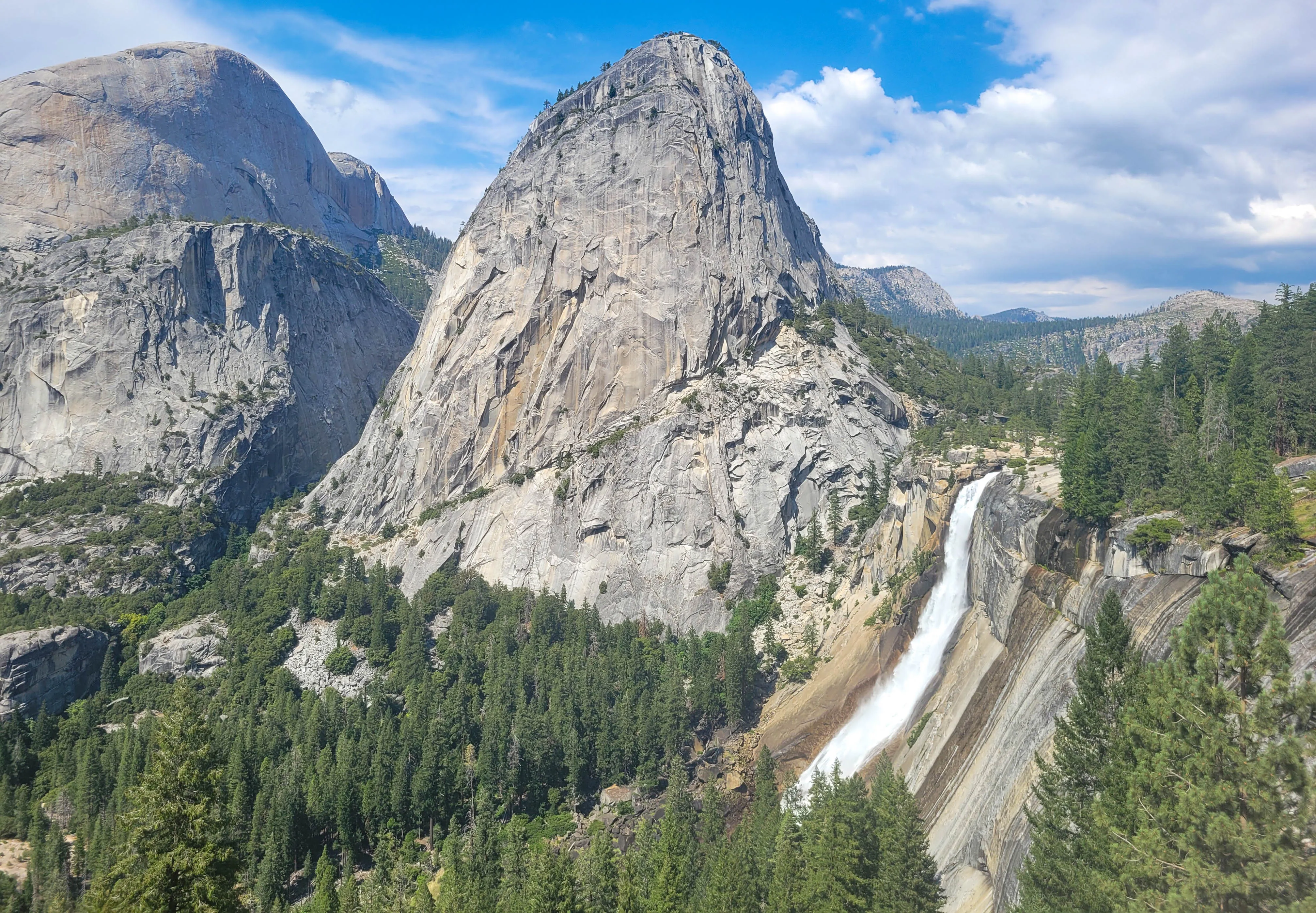
Mist Trail is steeper and contains several steps that can be slightly wet, hence the name, due to the close proximity to Vernal Fall. At the top of Vernal Fall, there will be a scenic view of Merced River.
The trail starts to level out as you approach the campground. This is another option for overnight stay but requires lugging camping gear for 4.5 miles. The campground is a nice place to rest and fill up on water. Although, to get to the river, a slight detour is required.
Once back on the trail, the dome will start to peak out in the distance.
The trail will start to get a bit steeper with switchbacks until you eventually reach the subdome where there will be some friendly park rangers at the base checking for reservations. The final stretch begins.
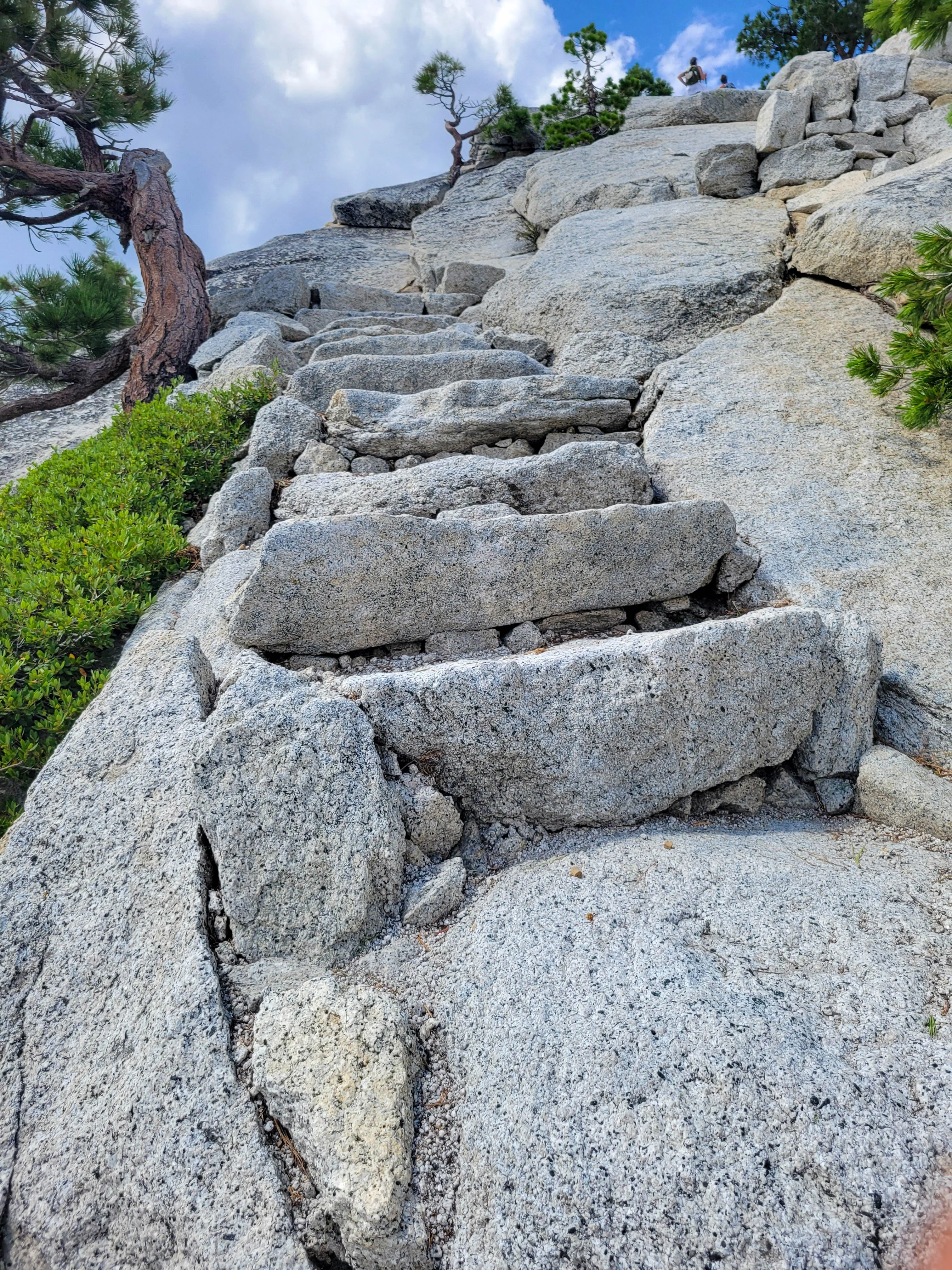 The subdome is actually quite steep with never ending staircases but it’s nothing compared to the dome. Don’t get too distracted by the view.
The cables section was probably the most tiring. My arms were starting to give out so a lot of it was just resting. There isn’t a lot of space to give way to those coming down or those who want to pass. After doing this portion, I would say gloves are a necessity and have saved me from slipping right off.
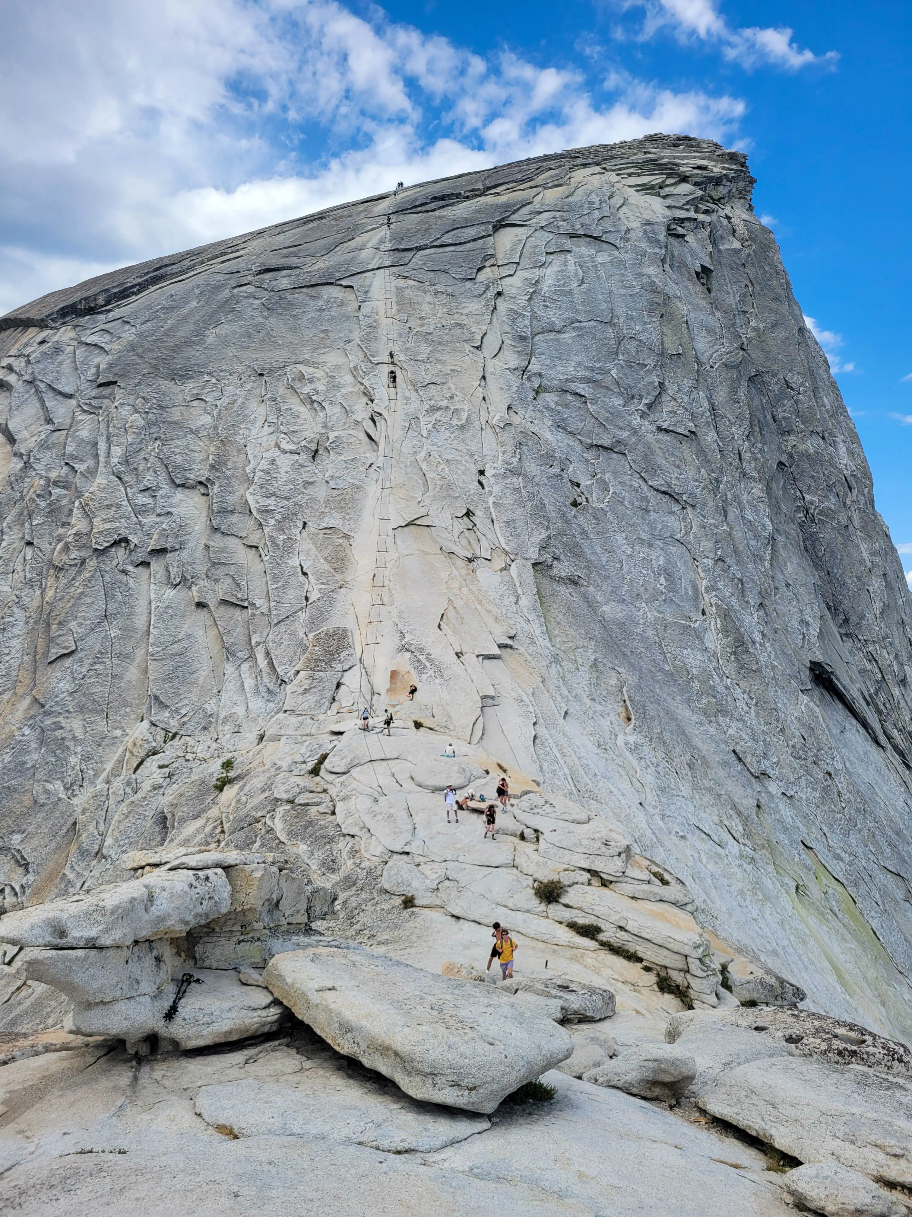
Pro tip: Leave your backpack at the bottom right before the cables. This would really help take the weight off and ease any fears of dropping things.
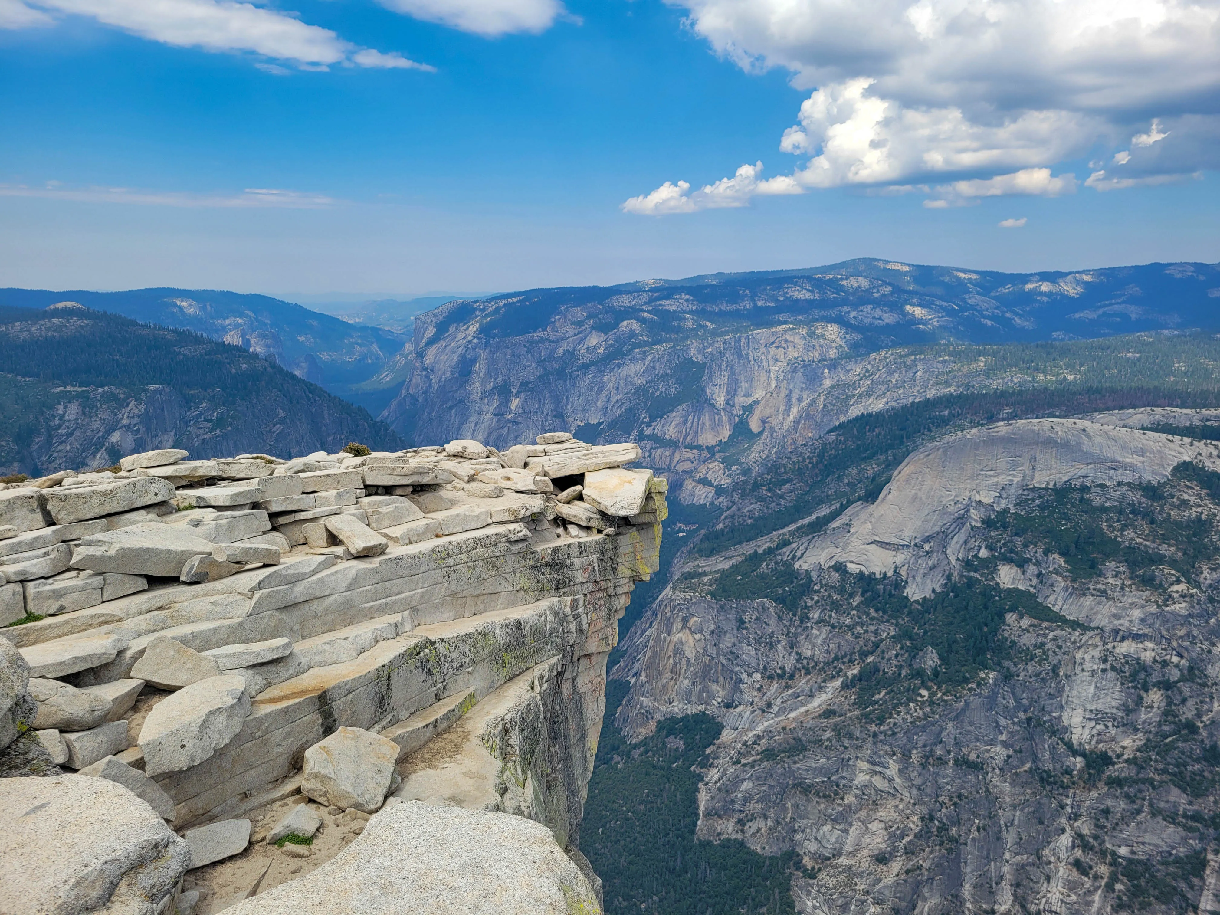
Getting to the top is well worth it. There is a lot of space to explore and take photos at one of Yosemite’s many cliff views. Hiking with chains is also just very appealing.
I thought the way back down was a lot easier but not many share that sentiment. I have seen people go down backwards, which may help.
At the junction, John Muir Trail will take you to Nevada Fall where you will see several people taking a dip in the water. This may have been be the most crowded section of the entire hike.
This portion is a series of switchbacks and is a bit longer than Mist Trail. Eventually you’ll reach the bridge again and the hike is essentially over at that point. This took us a total of 12 hours, which is a bit longer than I had hoped but at least we made it back before sun down.
Warning
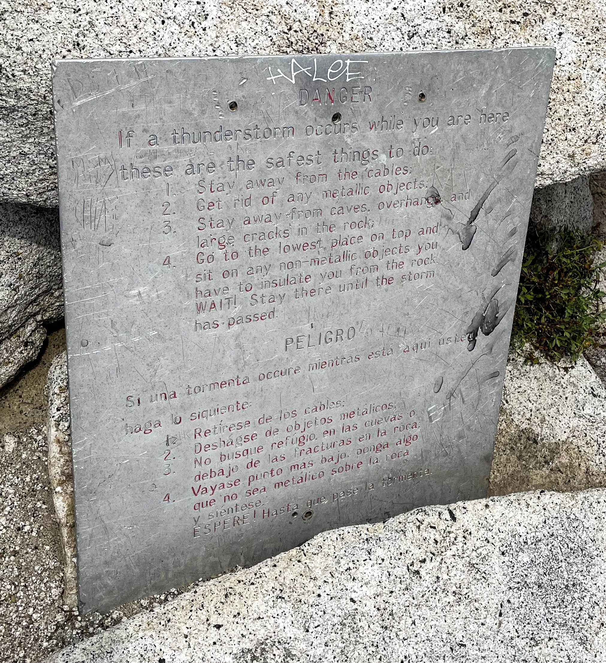
If there is a storm forecast, do not attempt the climb. If there are clouds in the distance, it will catch up quickly and you may get stuck at the top. At least, that’s what the rangers had warned.
Luckily, there are instructions at the top when trapped in a storm.
 It did end up raining a bit but only after we sped ran up and down. We were the only group at the top and the last group down but honestly… we could have stayed longer.